
Severe Tropical Storm Francisco, internationally named Mekkhala, is intensifying over the Philippine Sea and could become a typhoon later today. PAGASA warns Wind Signal No. 1 may be raised in Northern Luzon by Monday.
The intensity of Severe Tropical Storm Francisco, internationally known as Mekkhala, is nearing typhoon category as it moves over the Philippine Sea, the Philippine Atmospheric, Geophysical and Astronomical Services Administration confirmed on Sunday, June 21. PAGASA said Francisco will be classified as a typhoon once it reaches maximum sustained winds of 118 to 184 kilometres per hour, a threshold it is now closing in on rapidly.
While the storm remains far out at sea and is not expected to make landfall, its outer bands and the southwest monsoon it is enhancing are already prompting weather warnings across Northern Luzon and beyond.
Current Position and Strength
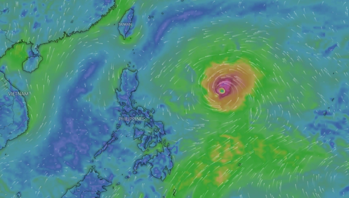
As of Sunday’s 11am bulletin, Severe Tropical Storm Francisco had maximum sustained winds of 110 kilometres per hour and gustiness of up to 135 km/h. At 10am, PAGASA placed the storm’s centre 1,170 kilometres east of southeastern Luzon, moving northwestward at 25 km/h.
The storm has been intensifying steadily through the weekend. As of 4am Sunday, Francisco’s centre was estimated at 1,315 kilometres east of southeastern Luzon, with maximum sustained winds of 100 km/h and gusts of up to 125 km/h, with strong-to-storm-force winds extending up to 420 kilometres from its centre. That represents a steady climb in strength over just a matter of hours, underscoring how quickly Francisco has been gathering energy over the warm waters of the Philippine Sea.
Francisco is the Philippines’ sixth tropical cyclone for 2026, and the second for the month of June.
How Francisco Formed and Entered PAR
The system that would become Francisco formed outside the Philippine Area of Responsibility on Friday, June 19. Its international name, Mekkhala, was contributed by Thailand and refers to the “angel of thunder”.
Mekkhala intensified from a tropical storm into a severe tropical storm outside PAR at 8pm on Saturday, June 20, then entered the Philippine Area of Responsibility at 10pm that same night, at which point it was given the local name Francisco. According to DOST-PAGASA’s Tropical Cyclone Bulletin No. 1, issued at 11pm on Saturday, the storm’s centre was estimated at 1,295 kilometres east of southeastern Luzon, with maximum sustained winds of 95 km/h, gustiness of up to 115 km/h, and a central pressure of 990 hPa, moving westward at 25 km/h.
Forecast Track: Where Is Francisco Headed?
PAGASA’s outlook suggests Francisco will remain a primarily open-water system throughout its lifespan, though forecasters are not ruling out a closer approach to the northernmost tip of the Philippines.
Francisco is forecast to remain over the Philippine Sea throughout its lifespan, continuing to move west-northwest until Tuesday, June 24, before slowing down and turning northward. The storm is expected to move west-northwestward until Tuesday, June 23, before slowing and recurving north-northeastward for the remainder of the forecast period.
PAGASA has said a landfall scenario is less likely at this time, but the storm could be near land on Tuesday, June 23, and Wednesday, June 24, meaning the future Francisco might affect weather in extreme Northern Luzon starting Tuesday.
PAGASA said Francisco is expected to continue gaining strength over warm ocean waters, possibly becoming a typhoon on Sunday and reaching peak intensity by Monday or Tuesday before gradually weakening. The storm could leave the Philippine Area of Responsibility as early as Friday, June 26.
Wind Signal Warning for Northern Luzon
Although Francisco itself is staying offshore, its sheer size means its outer circulation could still bring tropical cyclone wind signals to parts of the country.
PAGASA said a landfall scenario remains less likely, but as the weather disturbance moves closer to Northern Luzon, its outer circulation may trigger the hoisting of Tropical Cyclone Wind Signal No. 1. “Based on the latest forecast track, Wind Signal No. 1 may be hoisted in some localities in the northern and eastern portions of Cagayan, Babuyan Islands, and Batanes by tomorrow morning,” PAGASA said.
That timeline places the possible wind signal at Monday, June 22, just a day after Sunday’s bulletin.
Enhanced Southwest Monsoon: The Bigger Immediate Concern
For most of the Philippines, Francisco’s biggest impact in the coming days will not be wind, but rain, delivered indirectly through its interaction with the seasonal southwest monsoon, locally known as habagat.
While PAGASA said Francisco is unlikely to directly affect weather conditions in the country on Sunday, the storm is expected to enhance the southwest monsoon, which may bring heavy rains starting Monday, June 22.
PAGASA warned that the enhanced southwest monsoon is expected to bring heavy rains over Northern Luzon and parts of western Luzon and the Visayas starting Monday. “A Weather Advisory may be issued today in anticipation of the heavy rains over Northern Luzon and some areas in the western portions of Luzon and Visayas,” the agency said. The southwest monsoon is also expected to bring strong to gale-force gusts across several areas in the coming days, including portions of the Visayas, Mindanao, and Southern Luzon.
PAGASA had earlier said the Southwest Monsoon, or Habagat, may bring strong to gale-force gusts to Siquijor, Camiguin, and the southern portions of Davao Oriental, Davao Occidental, and Sarangani.
Sea Conditions and Safety Advisories for Mariners
PAGASA has also issued guidance for those at sea as Francisco continues to churn through the Philippine Sea.
PAGASA said moderate seas of up to 2 metres may be experienced over the eastern seaboards of Dinagat Islands, Siargao-Bucas Grande Islands, Surigao del Sur, and Davao Oriental. Mariners of motorbancas and similarly sized vessels are advised to take precautionary measures when venturing out to sea, and to avoid navigation under these conditions if possible. Other coastal waters are expected to have wave heights of less than 2 metres.
PAGASA urged the public and local disaster risk reduction and management offices to take all necessary measures to protect life and property.
A Hot and Stormy Sunday Across the Philippines
Francisco’s approach has coincided with another weather extreme entirely unrelated to the storm itself. PAGASA said 39 areas may experience danger-level heat index readings of between 42 and 45 degrees Celsius on Sunday, a sharp reminder that even as a typhoon brews offshore, large parts of the country are simultaneously contending with extreme heat.
Adding further complexity to the country’s weather picture, tropical cyclone Domeng, internationally named Jangmi, has separately intensified into a typhoon, though it currently poses no immediate threat to land. The Philippines, sitting in one of the most active tropical cyclone basins on Earth, is once again tracking multiple weather systems simultaneously as the 2026 typhoon season builds momentum.
PAGASA’s monitoring of Francisco will continue through the coming days as the storm approaches its expected peak intensity. The agency’s outlook places that peak at either Monday, June 22, or Tuesday, June 23, after which the storm is expected to begin a gradual weakening phase as it recurves away from the Philippines.
For residents of Cagayan, the Babuyan Islands, and Batanes in particular, Monday morning will be the key moment to watch, as that is when PAGASA’s current forecast suggests Wind Signal No. 1 could first be raised. Europeans24 will update this article as PAGASA issues further bulletins on Francisco’s track and intensity.