
The ground in Mexico City is sinking 2 cm every month: NASA verifies a concerning pace of subsidence. According to recent data obtained from numerous studies, Mexico City is one of the metropolises with the most ground sinking in the world.
The National Aeronautics and Space Administration (NASA) has reported that Mexico City is sinking by up to 2 centimetres each month in various regions. These conclusions were revealed following an analysis of data collected between October 2025 and January 2026.
Based on satellite image analysis, the eastern region was identified as one of the places where soil sinking is developing at an alarmingly rapid rate. One of the most likely causes is overexploitation of the aquifer.
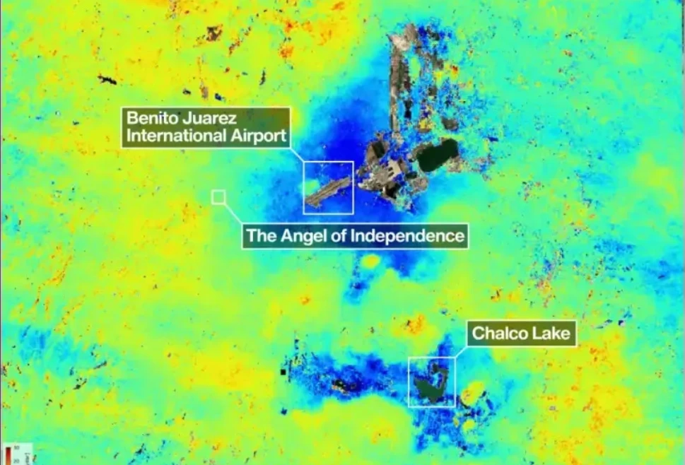
According to information available from NASA, it appears that the areas near the Benito Juárez International Airport and Lake Chalco are the areas with the greatest depression.
The discovery was made after carefully analysing photos collected by the NISAR Earth observation radar satellite, a technology capable of recording even the slightest changes to the Earth’s surface and tracking movement in real time.
It has a dual-band radar that can detect orographic changes as tiny as a centimetre. One of its main advantages is that neither cloud cover nor vegetation interfere with its tracking. This spacecraft was launched in 2025 as a collaborative effort by the United States and India.
Examining the land where the Megalopolis is located revealed an alarming rate of sinking of up to two centimetres each month. According to NASA data, the areas around Benito Juárez International Airport and Lake Chalco are experiencing the most depression.
The United States Agency centred the tool on Mexico City owing to the topic’s relevance and interest, with the goal of testing the correctness of this technology and comparing it to information existing at the time, collected via various studies and methodologies.
It is general knowledge that the Mexico City metropolitan region, which is home to around 20 million people, is constructed on top of an aquifer. The huge weight placed on the land, along with intense groundwater pumping, has caused the lakebed to compress for more than a century.
The Angel of Independence on Paseo de la Reforma is a notable monument that serves as a visual warning of ground sinking. This monument was constructed in 1910 to mark Mexico’s centenary; due to sinking, 14 steps have been added to its base.
Several generations of space-based radars have tracked the movements of Mexico City. “This city is a known hotspot for subsidence; images like this are just the beginning for NISAR,” stated the NISAR team’s Research Project Manager.
NASA aims to use this technique to foresee calamities. The enormous number of maps confirm the worrisome condition that Mexico City is now experiencing. This new research is based on NISAR observations gathered from October 2025 to January 2026, during Mexico City’s dry season.
NASA and the Indian Space Research Organisation (ISRO) collaborated to construct the NISAR project, which launched from the Satish Dhawan Space Centre on India’s southeast coast. This is the first spacecraft to carry two instruments that operate at distinct wavelengths.
It is capable of monitoring the Earth’s icy and terrestrial surfaces twice a day. It captures data using a 12-meter-wide drum-shaped reflector. It is the biggest radar antenna reflector NASA has ever launched into orbit.