
Get the latest on Hurricane Erin’s formation, its projected path, and the potential impacts on the Caribbean and the U.S. East Coast. Stay informed with our expert analysis.
The Rise of Erin: The First Major Threat of 2025
The 2025 Atlantic hurricane season has officially entered its most active phase, marked by the formation of Tropical Storm Erin. Now, meteorologists are closely monitoring its development, predicting it could become not only the first hurricane but also the first major hurricane of the season.
This storm, which originated as a tropical wave off the coast of Africa, is a powerful reminder of the risks and volatility of peak hurricane season. This article provides a comprehensive timeline of Erin’s development, its projected path, and the potential impacts for residents in its forecast cone.
A Timeline of Formation and Intensification
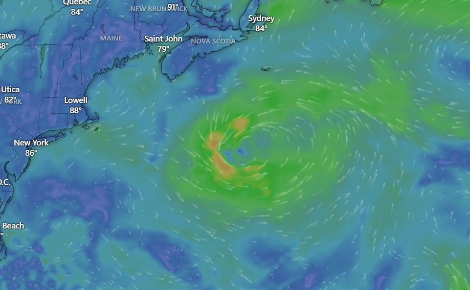
The story of Hurricane Erin began as a cluster of thunderstorms and showers, a typical “tropical wave” that moved off the coast of West Africa. The National Hurricane Center (NHC) began tracking this disturbance, designated as Invest 97L, over the weekend.
- August 10, 2025: The disturbance gains organisation, forming a tropical rainstorm near the Cabo Verde Islands. Favourable conditions, including warm sea-surface temperatures and low wind shear, fuelled its growth.
- August 11, 2025: The system officially strengthens into Tropical Storm Erin, the fifth named storm of the season, with maximum sustained winds of 45 mph. Forecasters note that the conditions are ripe for a period of rapid intensification.
- August 12-13, 2025: Projections indicate Erin will continue its westward to west-northwestward track across the central Atlantic. During this time, it is expected to strengthen into a Category 1 hurricane.
- Late August 14 – August 15, 2025: The forecast models show Erin intensifying further, with many predicting it will reach major hurricane status (Category 3 or higher, with winds over 111 mph). This would be a significant and rapid escalation.
The Path of Uncertainty: Steering Currents and Potential Impacts
As with any long-range forecast, the exact path of Hurricane Erin remains uncertain. The storm’s future trajectory will be largely determined by large-scale atmospheric patterns, particularly the location and strength of the Bermuda High, a massive area of high pressure in the Atlantic.
- Caribbean and Bermuda: The current forecast suggests that Erin will likely turn to the north before it reaches the Caribbean islands. However, it is still expected to bring rough seas, dangerous rip currents, and squalls to the northeastern Caribbean, including Puerto Rico and Hispaniola. Residents in Bermuda and the Bahamas are also advised to monitor the storm’s progress closely.
- U.S. East Coast: The key factor for a potential U.S. landfall will be how the Bermuda High interacts with a cool front and dip in the jet stream near the Atlantic Coast. If the Bermuda High remains strong and extends westward, it could block Erin’s northward path and steer it closer to the U.S. coastline. However, if the high weakens or a cold front pushes it away, Erin is more likely to recurve into the open Atlantic. Forecasters stress that it is far too early to predict any specific landfall threat with confidence, but an increase in rough surf and rip currents along East Coast beaches is a likely outcome by next weekend.
Staying Prepared and Informed
As Hurricane Erin develops, it serves as a critical reminder for all residents in hurricane-prone regions to review their preparedness plans. The long-range nature of this storm’s journey means there is still time to prepare, but complacency is the greatest risk.
Stay informed by checking the latest advisories from the National Hurricane Center and your local meteorological services. Have a family plan in place, prepare a storm kit, and know your evacuation routes. While a potential U.S. landfall is still days away, the time to prepare is now.